

Van's Air Force

The definitive Van's Aircraft support community! Buying, building or flying an RV? Join our exclusive family of mentors and enthusiasts!

ForeFlight Enhanced Airport Diagrams

DeltaRomeo

doug reeves: unfluencer
Staff member
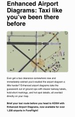
A screen grab of what just hit my inbox, FYI. Seems like something is being announced every few hours here before the big show 😊

IMG_2159.jpeg

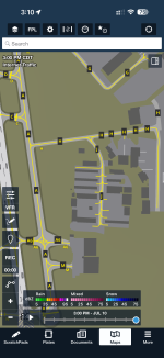
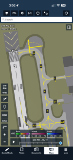
And it turns out it just showed up on my phone. Screen grab:
IMG_2160.png
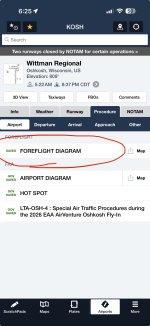
IMG_2161.png

Amazing world we live in.
v/r,dr

PS: Drooling over the Garmin AXIS announcement. That thread already has 13,000 views - what amazing technology!
 
Last edited:
Can't wait to use that. I confess I predicted ForeFlight would go downhill after it was acquired by Boeing, and I have so far been quite wrong. It continues to be a great product with great service, as far as I can tell.
 
Can't wait to use that. I confess I predicted ForeFlight would go downhill after it was acquired by Boeing, and I have so far been quite wrong. It continues to be a great product with great service, as far as I can tell.
Boeing sold ForeFlight together with Jeppesen, AerData, and OzRunways to the software-investment company Thoma Bravo for US$10.55 billion back in 2025 so maybe that’s why ForeFlight is getting good again. :)
 
I've checked home and two large airports in my state and can't see such things

How do you brief somewhere you are going? Or is it only zoomed in for where you are at?
 
I've checked home and two large airports in my state and can't see such things
I went into Apps and saw that ForeFlight had an update waiting for me. After the update installed, it looked like some things were downloading in the background - once I zoomed into a major airport, I could see taxiways labeled which weren’t labeled before.
 
I've checked home and two large airports in my state and can't see such things

How do you brief somewhere you are going? Or is it only zoomed in for where you are at?
It may depend on your subscription level too - I'm not sure for this, but often these features are only on the more premium subscription, so if you just use the standard level you may not see it.
 
Is this different from the garmin's SafeTaxi? It's hard to keep up with EFBs these days.
Still have both subscriptions..
It appears to be an overlay on your map. From the email, “clearer taxiway labels, hold-short markings, and hot spot details, all overlaid directly on your map.
 
Boeing sold ForeFlight together with Jeppesen, AerData, and OzRunways to the software-investment company Thoma Bravo for US$10.55 billion back in 2025 so maybe that’s why ForeFlight is getting good again. :)
So I might have been right!! 🤣
 
Now if I can just get my iPad to stop overheating….

Got taxi instructions from ground control. iPad and iPhone both overheated and were useless. I had to ‘fess up that I didn’t have taxi charts and had to get progressive taxi. 😳 Kind of embarrassing.

These enhanced taxi charts look awesome.
 
I have the Premium level with Jeppeson, but I don’t see these enhanced diagrams.
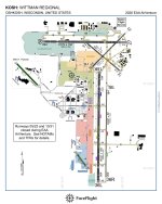
Wait, I DO see the diagrams. The Foreflight diagram doesn’t show up at every airport. For example, I see it on the airport diagrams for KOSH and KAUS, but not KDFW, KHOU, or KAFW Alliance. I suppose they’ll populate them to more airports in time.
 
For those that cannot see the latest airport diagrams, make sure you’re viewing them from the Map tab, and be sure that the Aeronautical layer is selected enabled. If you still do not see them, confirm that you have the July 9 Airport and NAV database downloaded from More > Downloads.
 
Wait, I DO see the diagrams. The Foreflight diagram doesn’t show up at every airport. For example, I see it on the airport diagrams for KOSH and KAUS, but not KDFW, KHOU, or KAFW Alliance. I suppose they’ll populate them to more airports in time.

All of those airports are supported by the new format. If you are not seeing it, follow my instructions above.
 
For those that cannot see the latest airport diagrams, make sure you’re viewing them from the Map tab, and be sure that the Aeronautical layer is selected enabled. If you still do not see them, confirm that you have the July 9 Airport and NAV database downloaded from More > Downloads.
Thank you for the instructions.

That is a layer that I typically have turned off because I found it to be too much clutter in the past.
 
For those that cannot see the latest airport diagrams, make sure you’re viewing them from the Map tab, and be sure that the Aeronautical layer is selected enabled. If you still do not see them, confirm that you have the July 9 Airport and NAV database downloaded from More > Downloads.
DUDE!!!
 
Thank you for the instructions.

That is a layer that I typically have turned off because I found it to be too much clutter in the past.
If you have the aeronautical layer selected, and you go into settings for the map, you can toggle on and off whatever you wish…
 
Back
Top