ShortSnorter
Well Known Member
I know there's always the Garmin Pilot vs ForeFlight debate, but ForeFlight8 looks impressive.
https://youtu.be/5ChSwhl4EUY
https://youtu.be/5ChSwhl4EUY


I know there's always the Garmin Pilot vs ForeFlight debate, but ForeFlight8 looks impressive.
https://youtu.be/5ChSwhl4EUY
I'm flying with ForeFlight v. 8.0.1 Pro and Stratus II v. 2.1. I absolutely love it! My iPad got me safely across the Country and back last year. I navigated several Class B airspaces and was able to dodge storms with confidence. The MOS forecast "images" for ceilings and visibility were always spot on. The geo-referenced taxi charts were a great help at unfamiliar airports. Well worth the money.
ksauce; For VFR work said:Agree this needs attention. i had a hard time "Pressing the airspace" without adding a waypoint
I don't like that the new maps do NOT display the private strips. In a forced landing situation I would like to know where they are.
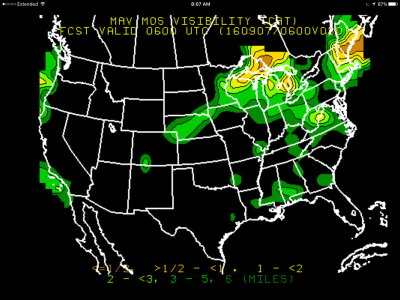
Sure thing. "MOS" stands for Model Output Statistics and is a magic numerical technique used to slice and dice weather model output and produce graphical guidance. On the bottom of your Foreflight screen, tap on "Imagery". Then over on the left of the screen there is a menu category reading "GFS MOS" and two subcategories "Ceiling Forecast" and "Visibility Forecast". Tapping Visibility Forecast, for example, will bring up thumbnails of the forecast charts for the entire US (in my case) from 6 hrs out to 84 hours out (!). The map is color-coded to represent visibilities from <1/2 mi. to 6 miles. Last year I flew across the Country and back and found both the visibility and ceiling forecasts to be excellent planning tools. They never once let me down. The only thing you have to keep in mind is that Visibility is ground visibility, and Ceiling doesn't tell you anything about the thickness of the layer. Well heck, a picture is worth a thousand words. I just picked this one at random:Could you elaborate on the MOS forecast images a bit.
All in all, it's hard to be disappointed with this update since it didn't cost any extra, but it's pretty hard for me to be excited about it either.
Its an extra cost to us. We have the Pro plan at $150 a year,and the new maps are not included. The Pro plan is no longer available and now you have to buy the Pro Plus plan at $200 a year or stay on Pro plan and not get the maps. There is new Basic Plus plan (basic plan discontinued) at 99 a year that includes new maps but it doesnt lacks some features we use.
I was able to maintain my $79 basic subscription when I renewed a week ago. I am sure the new maps are nice, but I find the sectionals to be adequate for my needs.
Larry
Would love to get Foreflight however the $US 200 ($CAN one million) is too much. Of course if Stratux works with it I might be persuaded. I read that there were difficulties with Ver 7. and Stratux
Currently using FltplanGo, I find from time to time allthough the Startux is connected to the App and it is reading numerous aircraft, they are not painted on the Map.
I was able to maintain my $79 basic subscription when I renewed a week ago. I am sure the new maps are nice, but I find the sectionals to be adequate for my needs.
Larry


