Van's Air Force

The definitive Van's Aircraft support community! Buying, building or flying an RV? Join our exclusive family of mentors and enthusiasts!

KOSH PIREP…Smoke?

Ironflight

VAF Moderator / Line Boy
Mentor
Doing my 24-hour-out-from-departure weather scan, and see that they’re talking MVFR for smoke all day tomorrow at Oshkosh - any reports from folks on the scene - is it starting to look/smell smokey? Low vis makes FISKE exciting…..

 
Doing my 24-hour-out-from-departure weather scan, and see that they’re talking MVFR for smoke all day tomorrow at Oshkosh - any reports from folks on the scene - is it starting to look/smell smokey? Low vis makes FISKE exciting…..

Nice & clear this morning, no smell nor reduced vis.
 
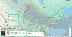
I took a look at WatchDuty (national wildfire site) and it appears there a bunch of stuff burning up n the Boundary Waters, so if the wind sets in from the north, that’s probably where they’r coming up with a smoke forecast. Good to hear there’s nothing in OSH yet!
 
Visibility at my local airport (KBRD) in central Minnesota is 1 3/4 miles in ”haze”. I stepped outside and it smells like an old ash tray. I can’t see across the lake that I live on. Oshkosh may be clear but people coming from the west may struggle a bit.
 
Since my earlier observation (and it may be psychological persuasion due to the dire reports above) there is a slight haze and maybe a hint of smoke smell 😟
 
i think its coming south. chicago TAF thinks the the lake effect breeze will keep it away here today, but will be here tomorrow with at least MVFR conditions. So, OSH is likely as bad or worse.
 
Visibility at my local airport (KBRD) in central Minnesota is 1 3/4 miles in ”haze”. I stepped outside and it smells like an old ash tray. I can’t see across the lake that I live on. Oshkosh may be clear but people coming from the west may struggle a bit.
Sounds like the fires are in Ontario with the smoke mostly moving East and South. Guessing this will be most prevalent in midwest and NE. hopefully it abates before the weekend traffic.
 
Sounds like the fires are in Ontario with the smoke mostly moving East and South. Guessing this will be most prevalent in midwest and NE. hopefully it abates before the weekend traffic.
Winds from the northeast are bringing us smoke from the both the Ontario fires and the fires in Superior National Forest/Boundary Waters Canoe Area. The BWCA may be too far south to smoke up Oskosh, not sure about the 800,000 acre fires in Ontario.
 
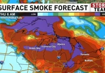
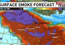
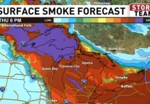
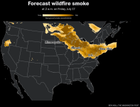
Surface smoke forecast for Thursday from upnorthlive.com (news)
 

Attachments

  • c283acd1-932d-4c77-b959-b3ce22c608a0-6AMTHUSURFACESMOKEFCST.webp
    c283acd1-932d-4c77-b959-b3ce22c608a0-6AMTHUSURFACESMOKEFCST.webp
    30.1 KB · Views: 96
  • 4405ccc9-f3fc-4b5c-a6e7-720a80634a79-12PMTHUSURFACESMOKEFCST.webp
    4405ccc9-f3fc-4b5c-a6e7-720a80634a79-12PMTHUSURFACESMOKEFCST.webp
    29.4 KB · Views: 91
  • 31c497db-6f8d-40bf-aaea-f1cb0ce1e9e8-6PMSURFACESMOKEFCST.webp
    31c497db-6f8d-40bf-aaea-f1cb0ce1e9e8-6PMSURFACESMOKEFCST.webp
    31.3 KB · Views: 91
I’m near KUES, 50 miles south of KOSH. Within an hour it went from severe clear to choked with smoke and marginal conditions. Pretty dramatic actually.
 
Oh wow! Be safe folks! Don’t press your luck with this stuff! Sure hope that moves out because if it doesn’t, there may be some serious incidents.
 
I was there today to do my Bell 47 recurrent training. It was MVFR. Really poor visibility. Reports were it was going to get worse over the next few days. It was hot there with very little wind causing the smoke to linger. Not good and could really mess up the arrivals. I'll be back for the show on Friday and hope it clears.
 
The smoke came over Oshkosh pretty quickly this afternoon around 1PM. I went up around 3PM to give a ride, tower was calling 3 miles visibility and that was awfully generous. Shortly after I landed the field went IFR and stayed that way all afternoon. We’ll see what tomorrow brings, TAF is looking a little better. The one bright spot is that the oppressive heat broke a little when the smoke came. Down to 79F at 10PM in Scholler, not too bad. It was still 90 this time yesterday.
 
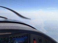
I spent a few hours in the smoke today. Kfld heading west. Smoke got progressively worse with some fields reporting 1sm. The vis varied but the best part is it burns in your eyes…. Very clear line once through it and on the west/south side. Be careful.
 
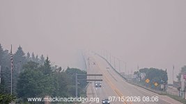
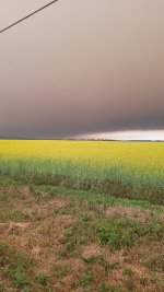
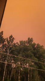
A large part of Northwestern Ontario is on fire, as well as some fires in Northern Minnesota. These pictures are from my place in Thunder Bay. Not that far from OSH. Check the forecast before leaving! Be safe.


IMG_0590.jpeg20260714_181804.jpeg20260714_190807.jpeg
 
I remember a few years back when there was smoke after we departed Oshkosh. I was impressed with how variable and unpredictable the effect could be from one moment to the next, when turning toward or away from the sun, etc. It is absolutely possible to go full IMC in this stuff, so be ready.
 
Eye burning smoke in northern Wisconsin. Same condition reported by a friend living south of Milwaukee. Plus it is infiltrating homes. Not your typical wildfire smoke situation.
 
As of 9AM it’s still 1 mile viz on the field. The smoke is as thick and heavy as I’ve ever seen it in Wisconsin.

We’ve come up with a new procedure for ground ops. Instead of HBC or HBP signs, you need to indicate Smoking or Non-Smoking. Non-Smoking spots are pretty hard to come by.
 
Over the last few years we've had to deal with Ontario wildfire smoke fairly often up here, central and northern Minnesota. The thing I've noted is that enroute visibilities are not consistent and not reliably predictable. In the course of a 1.5 hour cross-country flight last year I saw them go intermittently from 5 mile to 1 mile and everything in between. Route planning even using enroute ASOS/AWOS's can still be a crap shoot. I would take the smoke "forecasts" with a huge grain of salt and make sure of alternate airports. Deviating for smoke isn't the same thing as deviating for convective weather.
 
When the smoke eventually clears I hope this year's airshow performers consider toning down their smoke system output.

Looking at you Titan Team!
 
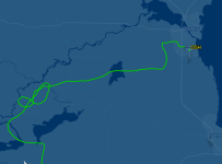
Folks be careful. As mentioned IFR conditions with vis ranges from 1 to 1-3/4 miles has been prevalent over the past 24 hrs. There has already been at least one case of continued VFR into IMC with an ATC save -- don't be that guy and put ATC into that position.
 
As Ironflight probably already knows but I’ll share with others, the automatic visibility detectors on AWOS, ASOS etc. do a poor job of reporting true visibility when looking through smoke. Many times out here in the west, during smoke events, the AWOS was reporting 5 miles visibility but the real visibility was much less….be careful out there.
 
  • Like
Reactions: JP4
Over the last few years we've had to deal with Ontario wildfire smoke fairly often up here, central and northern Minnesota. The thing I've noted is that enroute visibilities are not consistent and not reliably predictable. In the course of a 1.5 hour cross-country flight last year I saw them go intermittently from 5 mile to 1 mile and everything in between. Route planning even using enroute ASOS/AWOS's can still be a crap shoot. I would take the smoke "forecasts" with a huge grain of salt and make sure of alternate airports. Deviating for smoke isn't the same thing as deviating for convective weather.
Spot on.
A simple rule of thumb for VFR flight here in the West is that you can work around weather and get almost anywhere if you have a few days. That rule goes out the window with smoke. I’ve seen Central Oregon shut down for weeks for smoke. So, if you do make it to Osh, have a plan to leave your airplane for while.
Also, you can have VFR conditions and fly right over the top of near zero visibility smoke. All you see is the ground fade away. Very disorienting. It is different than any other weather phenomena I’ve flown in.
 
As Ironflight probably already knows but I’ll share with others, the automatic visibility detectors on AWOS, ASOS etc. do a poor job of reporting true visibility when looking through smoke. Many times out here in the west, during smoke events, the AWOS was reporting 5 miles visibility but the real visibility was much less….be careful out there.
Just fly over here to Shady Cove to prove your theory...
 
Im on the other side of the lake and the smoke is really heavy today. It has been MIFR or IFR all day and isnt looking better for Friday or maybe even Sat. Im hoping I can fly over Monday and come into OSH on Tues but it is looking like that may not work. I REALLY do not want to drive!! 8 hours drive or 2:15 min flight!
 
As of 9AM it’s still 1 mile viz on the field. The smoke is as thick and heavy as I’ve ever seen it in Wisconsin.

We’ve come up with a new procedure for ground ops. Instead of HBC or HBP signs, you need to indicate Smoking or Non-Smoking. Non-Smoking spots are pretty hard to come by.

1784224367189.pngDoctors are recommending that pilots should smoke a few cigarettes before flying to OSH (to acclimate respiratory system).
 
As I was driving by early this morning, our airport KBRD METAR was calling 5 miles (20 minutes old) while at the same time the ASOS was reporting 1 1/4 mi. The ASOS was accurate. Now, both METAR and ASOS are reporting 1 3/4 miles, also accurate. We're apparently right on the southwest edge of the smoke as both the airport 20 miles west and the one 20 miles south are reporting clear and 10 miles. None of this is unusual for this time of year. Between local forest fires and Canada which seems to be perpetually on fire, summertime visibility can vary widely

 
As I was driving by early this morning, our airport KBRD METAR was calling 5 miles (20 minutes old) while at the same time the ASOS was reporting 1 1/4 mi. The ASOS was accurate. Now, both METAR and ASOS are reporting 1 3/4 miles, also accurate. We're apparently right on the southwest edge of the smoke as both the airport 20 miles west and the one 20 miles south are reporting clear and 10 miles. None of this is unusual for this time of year. Between local forest fires and Canada which seems to be perpetually on fire, summertime visibility can vary widely
looking at the metars now on Skyvector and its still reporting IFR south of Milwaukee and Marginal 4 SM as far as Lacrosse. Farther than 20 miles out
 
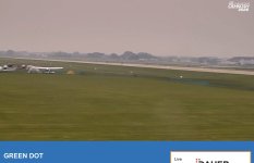
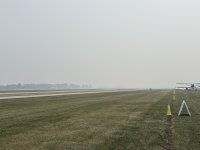
Wsquare Dot picture. Near Boeing Plaza. Looking south, offset from Rwy 18R. Approx 13:45 Central.
 

Attachments

  • IMG_8430.jpeg
    IMG_8430.jpeg
    3.4 MB · Views: 65
How is the breathing on the ground? AQI >300 according to grok, at some point that is a bigger issue
 
Back
Top