I have a small G3X mounted in portrait in my RV-8, and a Garmin autopilot. the magic all works great! I am trying to figure out how to program and fly a VNAV path. I do get the message "Approaching VNAV Path", but for some reason when I try to select VNAV on the autopilot, it doesn't light up, and there is no VNAV path in white (armed) on the scoreboard. I either have a programming error, or VNAV is not possible with the combination I have. Any thoughts out there?
Van's Air Force
You are using an out of date browser. It may not display this or other websites correctly.
You should upgrade or use an alternative browser.
You should upgrade or use an alternative browser.
VNAV Path
- Thread starter Terry Lutz
- Start date
Majorpayne317641
Well Known Member
Do you have a WAAS system? It may be that it won’t allow it without going into a certain mode on the approach.
Flavio Camelier
Member
Some tips
I have a G3X and no external navigators. I use VNAV a lot. The two most important things that need to be in place are: (i) the VNAV profile activated and (ii) the autopilot engaged in NAV mode (it doesn’t capture VNAV if it’s in HDG mode for example). Hope it helps.
I have a G3X and no external navigators. I use VNAV a lot. The two most important things that need to be in place are: (i) the VNAV profile activated and (ii) the autopilot engaged in NAV mode (it doesn’t capture VNAV if it’s in HDG mode for example). Hope it helps.
Thanks for the replies. My navigation source is a GPS175. It has been great for instrument approaches. What I would like to do is activate an approach beginning at a specific point (not vectors), then use VNAV to descend to that point at the specified altitude. I have good experience with Cirrus Perspective avionics, so I know what I should see on the scoreboard. But it just isn't there (yet!). With Perspective+ avionics there is an along track offset function, but I don't see that with my G3X or GPS 175 (yet!).
Mark33
Well Known Member
Thanks for the replies. My navigation source is a GPS175. It has been great for instrument approaches. What I would like to do is activate an approach beginning at a specific point (not vectors), then use VNAV to descend to that point at the specified altitude. I have good experience with Cirrus Perspective avionics, so I know what I should see on the scoreboard. But it just isn't there (yet!). With Perspective+ avionics there is an along track offset function, but I don't see that with my G3X or GPS 175 (yet!).
As I understand it, the GPS 175 won’t do a typical VNAV like a 650/750….or even your standalone G3x using its internal gps. The GPS 175 uses a different system, similar to VNAV, but not exactly the same, and when it’s being used as your navigation source, your G3x won’t recognize or initiate VNAV. There’s a Midwest Panel Builders YouTube video or two explaining this in more detail. The next time you fly, use the G3x internal GPS as your navigation source and you’ll see that VNAV works just fine. Then, switch to your 175 as your navigation source and the VNAV feature will go away.
Last edited:
Longez
Well Known Member
Terry,Thanks for the replies. My navigation source is a GPS175. It has been great for instrument approaches. What I would like to do is activate an approach beginning at a specific point (not vectors), then use VNAV to descend to that point at the specified altitude. I have good experience with Cirrus Perspective avionics, so I know what I should see on the scoreboard. But it just isn't there (yet!). With Perspective+ avionics there is an along track offset function, but I don't see that with my G3X or GPS 175 (yet!).
I have a GNX 375 installed with my G3X Touch system, and use G3X Touch VNAV all the time to descend, autopilot coupled, to the IAF on an active approach. You can do the same with your GPS 175.
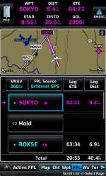
In this example the K81 RNAV 21 approach beginning at the SOKYO IAF was activated on the GNX 375 about 35 nm outside the SOKYO IAF. Note that I am using external navigation from the GNX 375.

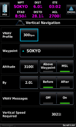
The aircraft is at 4,000 ft MSL when the approach was activated, and I want to descend to 3100 ft MSL at the IAF. Press the VNAV button on the GDU 4XX flight plan page to set this up.

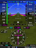
As shown in the flight director bar at the top of the PFD, I pressed the VNAV button on the GMC 507 to arm for VNAV capture for the descent. You can see in this example that the aircraft is almost at the top of descent for the VNAV profile and will automatically capture and fly this profile when the vertical deviation marker reaches the center.

Let me know if you have any questions.
Steve
Frankster13
Active Member
I had the same issue. It took several calls to Garmin but finally got a guy that helped me with my configuration settings. I love my VNAV! Call Garmin and have them walk you through the settings


