What's new
Van's Air Force

Don't miss anything! Register now for full access to the definitive RV support community.

Shrinking the Brain Bag....

Ironflight

VAF Moderator / Line Boy
Mentor
Fry's is a dangerous place......:cool:

ever since I finished the Val, I have been looking for alternatives to the paper approach plate bag - the RV-8 is a super personal traveling machine, but let's face it, there is just no way to take an entire continent's worth of approach plates on every trip. I have a little "trip bag" that I have to load depending on where I am going, and if it is a long trip in multiple directions, I sometimes have to throw extra books in the back and swap them out - a real pain. Consequently, I have been actively looking for electronic solutions for a couple of years now, and have been keeping my eye on the "E-Ink" devices. I have gotten mixed reviews on the supportability of the early models (although everyone says the display s great!), and I just wasn't ready to sink the kind of money they wanted into an experiment.

Then yesterday, I stopped at Fry's to get some tax software and Wham! I walked by the latest Sony ready display - now priced at $299!! the last time I'd checked, they were twice that price, and the software was a bit skimpy. I did some quick-in-store research, went home and looked a bit more on line, and went back for one. Why now? Price, the ability to read PDF's,and the fact that you can get all the US approach plates on line in PDF format for free!

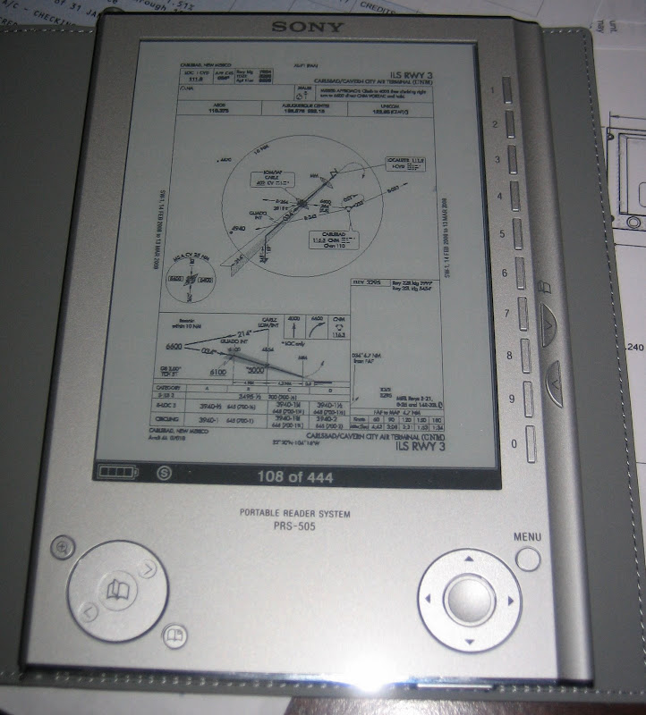
OK, so how does it look?
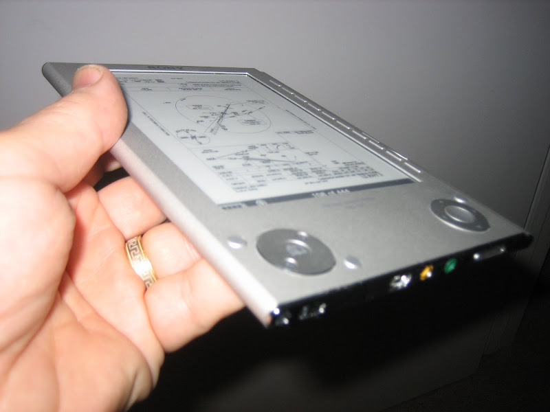
IMG_2148.jpg


Thickness?

IMG_2153.jpg


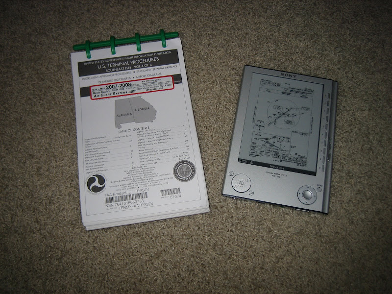
Compared to a NOS book?

IMG_2151.jpg


OK, all I have done with it so far is play with it at home, and load a couple of Gig's worth of plates. Haven't had it in the cockpit yet, but here are a couple of observations:

1) the display is smaller than a standard approach plate, but is very crisp and readable. Yes, you'll need good reading glasses or visual acuity - but the data is all readable!

2) All the approach plates for 50 states fits in about 3.5 Gigs of storage space. this unit has an SD card slot that will take up to a 2 gig card. I have built two cards - one east, and one west - so I have the entire brain bag in one little package.

3) A large state worth of plates can be a little difficult to navigate - you don't get instant retrieval - but then again, if you are planning ahead, you shouldn't need it in an instant. My concept of operations is that I will leave th e"total US" on the SD cards, so I have everything with me all th time. then for each trip, I can build a unique file with the airports I intend to use - that will make access very quick. Initial tries at this are promising.

4) If you get stuck someplace due to weather - use it like it was intended - read a book! (I already loaded up the AIM and the Instrument Flying Handbook as "lite" reading.)

This is not perfect for PDF's - the scaling can get a little tiny - but it sure appears to me to be better than juggling a huge brain bag of books. Since I already subscribe to Air charts update service, I can download charts once a year to coincide with the annual "drop" and use the update sheets to know that I have the latest data. I'm not saying this is the be-all, end-all solution....just a cool step in the right direction!

Hopefully, I'll get a chance to play with this in the air in the next couple of days - but it's a stormy afternoon here in Houston.....

Paul
 
For those who are interested, if you purchase through Sony's website, you can get a 3-year accidental damage protection plan for $70. Also, they'll engrave it!

Mike
 
How to Dowload Charts

So how do you download your charts???

I assume you use your pay service right???

There is no easy way to download from the FAA yet. You have to download them one at a time currently, right?

Does anybody know anything different??

David T.
 
So how do you download your charts???

I assume you use your pay service right???

There is no easy way to download from the FAA yet. You have to download them one at a time currently, right?

Does anybody know anything different??

David T.

Take a look at the thraead that Mike referenced above - that's where I found:

http://www.nacomatic.com/

It took just a couple hours to download everything, and it has cool utilities for doing specific airports and regions - all free! (This is what got me thinking about this again, and then I walked by that display at Fry's....)

Paul
 
Oh my I'm drooling

Wow paul I don't know what to say...Except that 4 days ago I just ordered my Sporty's paper plates.

Gee you got me thinking buddy..I will be interested in how easy it is to retrieve the plates from the little box in a timely manner.

Then there is the thorny question of what to do if the unit goes "Phut" at some slightly inconvenient time..Like anytime your fying in IMC for example...:D

Frank
 
Then there is the thorny question of what to do if the unit goes "Phut" at some slightly inconvenient time..Like anytime your fying in IMC for example...:D

Frank

Well...that's why we have full databases in the approach certified GPS...right?:rolleyes:

In truth, about the only think I really need off the plates anymore (I mean REALLY NEED - I use a lot more) are the altitudes and vertical profile stuff. the horizontal guidance is all in the GPS database.

It's a brave new world!

Paul

(Oh, and thinking about how I usually do business, it is highly likely that I will still bring along a current paper approach plate for where I intend to go. I am not sure that i am ready to totally commit to a device like this yet, but see it more as a convenient way to carry the entire country with me all the time - just in case....)
 
Neat Stuff. As a VFR pilot, I can definitely see me getting one when the technology evolves to the point that I can view sectional chart detail by simply "dragging" the desired area into view such as the way http://skyvector.com/ is set up to do. :cool:
 
Doesn't work..

....for me, anyway.

Paul, I tried to download only Georgia...the little Windows flag waves but no prompting on where to download it to or any other prompts. Is there a problem with the site or am I doing/not doing something I should be doing?:)

Thanks,
 
Backup Information

These displays are great space savers but before commiting to a single EFB take a look at AC NO. 91-78.

Randy Hooper
 
Neat Stuff. As a VFR pilot, I can definitely see me getting one when the technology evolves to the point that I can view sectional chart detail by simply "dragging" the desired area into view such as the way http://skyvector.com/ is set up to do. :cool:

That's exactly what I was thinking. I like the way you can drag and move on Skyvector.com. If I could do that with this Sony device, I would jump in.

Karl
 
I'm the guy behind the NACOmatic website ... if you've got suggestions, please use the
'subscribe' button on the website. It only sends an email. I won't subscribe you unless
you explicitly request to subscribe.

Question re: the Sony eBook Reader

Does it properly display the bookmarks that I build into the PDF bundles?

-doug
 
DUH?

Pierre

Did you right click & "saver target as" to your computer?

....Thanks Sam......I guess I'm still a little computer challenged. ...man it's a slow download...47 minutes just for Georgia's approach plates..(128MB).on my fast computer...sheesh.

Regards,
 
....for me, anyway.

Paul, I tried to download only Georgia...the little Windows flag waves but no prompting on where to download it to or any other prompts. Is there a problem with the site or am I doing/not doing something I should be doing?:)

Thanks,

The files are large - they can take quite a bit of time to download.
I recommend using a <Right-Click> and <SaveTargetAs> dialog ... NOT
a <Left-Click>

-doug
 
> man it's a slow download...47 minutes

It all depends upon the nbr of people that are simultaneously downloading. Moments
ago ... there were 47 concurrent downloads occuring ... that's quite a load for a
Comcast/residential connection.

-doug
 
It goes PHUT...

1, print the hard copy for your intended landing and alt, still free rather than buying plates.

2, worst case ask for forgiveness from ATC and accept their help ie vectors to VFR or information required for the approach. Do you really think they'd violate you just because you need a couple hints??


I like Pauls solution and look forward to an EFB when I finally finish my IFR. I have a hard time swallowing the price of admission to the IFR system when you take plates, charts, GPS updates and everything else you have to have before you even leave the ground once. I mean come on, $500-$1000 for Jep/year, Garmin wants a mint and Gawd help you if you have twin GPS's to double the update costs, and on and on. Just to make a couple IFR flights a year. Even if you make 12-24 flights a year which is reasonable # for most GA pilots, thats an extra hundred bucks for each flight.

So thanks very much to Doug/Rainsux, I appreciate the service you're providing and the potential cost savings in this area.
 
> You might also consider going directly to the source:

Yabbut ... NACO limits you to downloading one-page-at-a-time. I found it to be such a
PITA that I build the state-by-state PDF bundles.

-doug
 
Last edited:
Hey Doug, noticed you are brand new here.

Welcome aboard, and thanks for the info you have/are providing.
 
Perfect!

I'm the guy behind the NACOmatic website ... if you've got suggestions, please use the
'subscribe' button on the website. It only sends an email. I won't subscribe you unless
you explicitly request to subscribe.

Question re: the Sony eBook Reader

Does it properly display the bookmarks that I build into the PDF bundles?

-doug

Hello Doug - thanks for a great site! Yup, the Reader displays the Table of Contents for each state, so you open the state as a "book", scroll through the TOC, and display the plate that you want. It's not lightning fast (this isn't a high-powered PC), but appears quite adaquate for this use.

I probably contributed to your traffic the other night when I basically downloaded the entire country between midnight and Oh-dark-thirty.....:D

Paul
 
Sony Reader

Paul, Thanks for bringing this up. It really got me thinking about going the electronic route too.
The current IFR Refresher has a good article on e-charts by Tom Gilmore. He wrote that as of 7/20/07, with Advisory Circular 91-78, the FAA established some guidance. This device falls into the Class 1 EFB area (Electronic Flight Bag) which doesn't require approval.
That said, I would agree that I'd be more comfortable w/ paper backup.
BTW I've filed AZ to FLA and AZ to KOSH and it does take a forest of NACO books.

I highly recommend IFR Refresher for good practical advice on IFR operations. [email protected]
 
> I probably contributed to your traffic ...

Paul,

No harm. No foul. No problem.

On a completely unrelated note - I'm gonna be with Dr. Apt this
weekend ... flying skiplanes. Care to share any info that I can
use to tug his chain? <g>

-doug
 
Last edited:
>
On a completely unrelated note - I'm gonna be with Dr. Apt this
weekend ... flying skiplanes. Care to share any info that I can
use to tug his chain? <g>

-doug

Dr. Apt?!

I have WAY to many stories that I could tell there....but then, he's probably got an equal number on me, so I think it would be safer to just tell him that I said Hi!;)

Enjoy,

Paul
 
>It all depends upon the nbr of people that are simultaneously downloading. Moments
ago ... there were 47 concurrent downloads occuring ... that's quite a load for a
Comcast/residential connection.

Doug,

If you're interested I offer my host up as a mirror. I've got tons of space and bandwidth that never get used. Send me a PM.
 
A second device would work for a backup. Still less to clutter the cockpit, and cost for an additional unit is less than a year's subscription. Is there a way to get one uploaded with charts and then sync to the other? I think very soon we'll all be moving towards electric charts.


Paul, Thanks for bringing this up. It really got me thinking about going the electronic route too.
The current IFR Refresher has a good article on e-charts by Tom Gilmore. He wrote that as of 7/20/07, with Advisory Circular 91-78, the FAA established some guidance. This device falls into the Class 1 EFB area (Electronic Flight Bag) which doesn't require approval.
That said, I would agree that I'd be more comfortable w/ paper backup.
BTW I've filed AZ to FLA and AZ to KOSH and it does take a forest of NACO books.

I highly recommend IFR Refresher for good practical advice on IFR operations. [email protected]
 
NACOmatic - Apology for Site Outage

All,

In the few days since VAF users have discovered my personal/home
webserver, your usage has *dwarfed* the combined download usage of
AOPA, CPA, CPS, BeechTalk & PurpleBoard ... combined.

I have moved the NACOmatic to a commercial hosting service this
morning. It looks like the DNS updates have been distributed to the
far corners of the internet.

If you bookmarked the site earlier; please refresh your bookmarks:

http://www.NACOmatic.com

Download speeds are ~10X faster.

-doug
 
Last edited:
bulk approach plate(s) link won't work

Hi,
I was downloading a few states IFR approach plates and today the link would not work. Does anyone have another that will work like the bulk download by states that was posted earlier?
Thanks.
Kenny Gene
 
Aviator Trip Pack software

Hi guys-

I found this site some time ago while looking into the practicality of an EFB. It synchronizes a local database of plates with the NOS site, and can produce a custom PDF of plates for a particular flight plan. I haven't played with it enough to endorse it, but it seems like a good idea.

Aviator Trip Pack: http://cmensys.com/

Dallas
 
Hey Paul,

I have the PRS-505 too. Great tool and my only complaint is the absence of any backlight for night.

If you look at STARs or Departures, can you see the graphical representation on yours??? Mine does not show any graphical representations. It's just a blank page with with text explanation.

Phil
 
Last edited:
Yup

Decided to keep my one years subscription and then see how much these notebooks are then.

Doug, you have done a wonderful service making these plates available...Thankyou so much!

Frank
 
NACOmatic - Preferred Routes DBMS Added

I spent Saturday playing with a SuperCub on skiis.

http://dranz.readyhosting.com/n172t.jpg

When the freezing rain arrived, I retreated to the warmth of
the bar and added a few things to the NACOmatic website:

- Preferred Routes database
- Region bundles for the A/FD.

-doug
 
If you look at STARs or Departures, can you see the graphical representation on yours??? Mine does not show any graphical representations. It's just a blank page with with text explanation.

Phil

I do see the SIDs and STAR graphics Phil, but I have noticed that I don't see the airport diagram down in the corner of approach plates. My guess is that they do it in some sort of a greyscale, and the Reader is only doing black or white? Doesn't seem to reduce th usefulness for approach plate info for me, but yeah - still a few bugs.

Doug - your site is just great! Glad that you got some hosting help - I'd hate to think we are all smoking your own computer....

Paul
 
Paul,

I looked at the Sony eBook Reader long ago ... and determined that it was not
satisfactory for *my* purposes. I was curious what others thought about it,
so I kept my yap shut to avoid biasing the discussion.

The Sony & Kindle use the same screen ... both are limited to four [count'm 4]
levels of color (black, dark grey, light grey & white). NACO is authoring the plates
to use more levels - dunno how many. Hypothesis: Some of NACO's greys are
being mapped to white by the Sony.

> smoking your own computer ...

No problem. I was curious if the residential cablemodem (1.544Mbps upload cap) was
discouraging usage. It was ...
 
Last edited:
For the geeks among us ...

I have uploaded a ZIP collection of batch files & the "wget" utility that will
download all the plates for an individual airport, directly from NACO's servers.

Follow the instructions precisely. (Use the command line.)

-doug
 
Last edited:
Those are heavy looking tracks

I spent Saturday playing with a SuperCub on skiis.

http://dranz.readyhosting.com/n172t.jpg

When the freezing rain arrived, I retreated to the warmth of
the bar and added a few things to the NACOmatic website:

- Preferred Routes database
- Region bundles for the A/FD.

-doug

Doug,

I just have to ask ... since nobody else did. In your photo above, you have some ATV aftermarket tracks next to the skis. Is this a joke, or are they actually attached to the plane? Looks like they are just placed next the skis. Cool looking though.

Hmmm... maybe replace my nosewheel with one of those tracks. :eek:
 
Nice idea :) I have a Nokia N800 (internet tablet, not a phone). It can take 2 x 8 GB SD cards. The newer version, N810, even has a built in GPS receiver.

N800
N810

It runs LINUX, and can read just about any file format you can think of, including e-books. Right now I connect my N800 to a bluetooth GPS and get online google maps via my phone (allso satelite photos). I had some thoughts about using it in the plane, but I considered it to be unpractical and redundant as well as unreliable, and google maps do not have the right kind of information anyway.

Using it for reading real maps and charts preloaded on the device sounds like a much better idea that I have to try.
 
> I just have to ask ... since nobody else did ... ATV aftermarket tracks

It's a sight gag. I was beginning to worry that nobody had (yet) called me on it. <g>

-doug
 
Last edited:
> Nokia 8XX

Please let us know if the plates are readable.

- Does it display ALL the text? Readable? (Some of NACOs greys map to white on some devices.)

- Does the PDF Reader allow using bookmarks?

- Is the bookmark/scrolling performance acceptable?
 
Not sure about bookmarks, but scrolling is done in all directions by dragging a finger on the screen, it is very fast. Zooming is done with zoom in - zoom out buttons.
 
Because the TX file is so large (400MB+); I have also broken it into three [3] pieces,
alphabetically by city name.

-doug
 
Back
Top