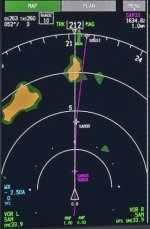
On most EFIS systems I’ve flown, the nav/map display includes range rings. This is a common and extremely useful feature that seems to be missing from G3X. As an example see the first pic. Right off the bat I can tell my display is in the 10 mile scale because of the “5” shown on the middle range ring. This allows the pilot to instantaneously and intuitively determine an approximate distance to everything on the screen. I can tell that SAM30 is about 4 miles away. I can tell the edge of that weather cell is about 7 miles away. Had any airports been displaying on the map, I could tell the appropriate distance to each one at a glance. Why doesn’t G3X have this basic feature? (Or if it does, please tell me how to activate it!)
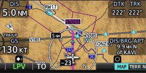
I have searched the G3X manual and can’t find it. The GNX375 has it, as shown on that screen shot. In the GNX375 manual they call it a Range Ring. If I search the G3X manual for that term, the only results are the Fuel Range Ring and Glide Range Ring. No map Range Ring that I can find.
Instead, to tell scale, G3X includes a small “Scale Bar” on the lower right corner of the screen. That is nowhere near as useful. To tell distance to an object with that, I’d have to estimate how many scale widths are between me and the object in question and multiply that by the current value of that scale. Yes, I know I can tap an object on G3X and see the distance, but that’s not as useful. With a range rings a pilot can estimate the distance to multiple objects at a glance, rather than tapping several objects individually. (Sometimes my hands are busy actually FLYING! )
)
This should be a simple feature to add. Just an arc and a number!


I have searched the G3X manual and can’t find it. The GNX375 has it, as shown on that screen shot. In the GNX375 manual they call it a Range Ring. If I search the G3X manual for that term, the only results are the Fuel Range Ring and Glide Range Ring. No map Range Ring that I can find.
Instead, to tell scale, G3X includes a small “Scale Bar” on the lower right corner of the screen. That is nowhere near as useful. To tell distance to an object with that, I’d have to estimate how many scale widths are between me and the object in question and multiply that by the current value of that scale. Yes, I know I can tap an object on G3X and see the distance, but that’s not as useful. With a range rings a pilot can estimate the distance to multiple objects at a glance, rather than tapping several objects individually. (Sometimes my hands are busy actually FLYING!
This should be a simple feature to add. Just an arc and a number!


